HomeStore
The Age of Exploration Maps Premium 24x36 Reference Poster - Useful Charts/World History Encyclopedia
The Age of Exploration Maps Premium 24x36 Reference Poster - Useful Charts/World History Encyclopedia
Take a deep dive into the world of Christopher Columbus, Amerigo Vespucci, and more, with this spectacular poster for your wall! This spectacular wall chart is the ultimate guide to the Age of Exploration, featuring maps from the amazing online resource World History Encyclopedia. At top-left is the map entitled "The World According To Christopher Columbus c.1490", which outlines Columbus' proposed route to Japan and China prior to launch in 1492. At top-right is the map entitled "Amerigo Vespucci's Voyages, 1499-1502". Across the middle is "The Voyages of Christopher Columbus 1492-1504". At bottom is "Map of the Spanish Main & the West Indies c.1720",outlining the Spanish, English and French possessions of the era, with the main New World cities marked, and the main sailing routes indicated. Designed to perfection of purpose by Vancouver-based historian Matt Baker, and printed on premium-quality gallery stock for durability and attractiveness, this is a true treasure. Seen in better libraries, classrooms, museums, and homes worldwide - add it to your décor today!
$8.73
Original: $24.95
-65%The Age of Exploration Maps Premium 24x36 Reference Poster - Useful Charts/World History Encyclopedia—
$24.95
$8.73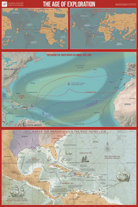
Description
Take a deep dive into the world of Christopher Columbus, Amerigo Vespucci, and more, with this spectacular poster for your wall! This spectacular wall chart is the ultimate guide to the Age of Exploration, featuring maps from the amazing online resource World History Encyclopedia. At top-left is the map entitled "The World According To Christopher Columbus c.1490", which outlines Columbus' proposed route to Japan and China prior to launch in 1492. At top-right is the map entitled "Amerigo Vespucci's Voyages, 1499-1502". Across the middle is "The Voyages of Christopher Columbus 1492-1504". At bottom is "Map of the Spanish Main & the West Indies c.1720",outlining the Spanish, English and French possessions of the era, with the main New World cities marked, and the main sailing routes indicated. Designed to perfection of purpose by Vancouver-based historian Matt Baker, and printed on premium-quality gallery stock for durability and attractiveness, this is a true treasure. Seen in better libraries, classrooms, museums, and homes worldwide - add it to your décor today!